The night was soft and thick and black and warm as velvet, silky on my skin, smelling of iodine and salt and crepe myrtle and that ineffable, skin-prickling saline emanation that says ‘ocean’ to me whenever I smell it, hundreds of miles inland. It always moves me close to tears, so visceral, so old and tidal is its pull. I have often thought that it is the first smell we know, the amniotic smell of our first, secret sea.” ― Anne Rivers Siddons, Downtown
*
We come from the sea, the sea inside, and perhaps we will return to the sea as well.
In the meantime, I spend as much time there as I can, literally and metaphorically. I was literally at the sea the last two weeks in December 2015, specifically the beach and Atlantic Ocean at Jekyll Island, GA.

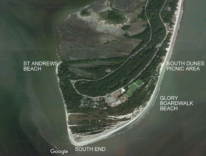
When we’re at Jekyll, we usually decide first which beach we want to visit (though they are all the same beach, of course), referring to locations by shorthand — Clam Creek (north end, which also includes the marsh), mid-island (from near our condo to South Dunes Picnic Area), south end (from Glory Boardwalk to south tip, around to St. Andrews Picnic Area) — and then we check the tides.
Parts of the ocean-side of the island, from south to north:


The tide is most important for the south end, from St. Andrews to the Glory Boardwalk area, where you can find yourself stranded at high tide, and for some of the mid-beach; on the north end, you can make your way inland if necessary (you can from the St. Andrews Beach, too, but it’s not easy). So we try to hit the beaches, and especially the south end, from two to three hours before low tide to one to two hours after it. And preferably not in the middle of the night.
*
In this post, I’ll focus on the beach at the south end of Jekyll, from St. Andrews Picnic Area to just south of the Glory Boardwalk/Soccer Field area. Following posts will look at the mid-beach and the north end. All photos were taken by me in December 2015.
*
ST ANDREWS / SOUTH END
People, and birds and dolphins, are usually fishing or shrimping on the beach at St. Andrews.


The beach, especially at the south end, is quite wide at low tide, and very narrow at high tide, and at St. Andrews there are a number of skeletonised trees on the beach.


Walking from St. Andrews toward the south end, you can see Little Cumberland and Cumberland islands nearby, and on the beach are often ghost crabs and other crabs; ghost shrimp holes; warblers, swallows, draongflies, butterflies, and other flyers (depending on the time of year) flitting among the nearby shrubs, grasses, and logs; egg cases; shells; sea whip (a kind of coral); and at the south end, large flocks of seabirds gathered to rest, or sometimes, just a lone heron hunting.


The sand in places is black and radioactive.


In other places, striated or channeled.


And always, exquisite.


The mast of a ship that sank offshore years ago is now firmly embedded in the beach sand, testament to the way barrier islands continuously shed sand from north to south, reducing beach on the north end and adding it on the south end.

It’s fun, and offers an interesting, slightly destabilising perspective, to stand on the southernmost tip of land at low tide and look out into the ocean, then back at Jekyll.


*
“Extract the eternal from the ephemeral.” — Charles Baudelaire
Leave a Reply